
Gas can also be partially dissolved in oil or fill the elevated part of an oil field, forming a so-called gas cap. Therefore, gas is often produced with oil and oil with gas.
Prospecting new fields is the job of geologists and geoscientists. They have technical and chemical means which help identify accumulations of hydrocarbons fairly precisely. However, the only way to know for sure is to drill a well.
One kilometer and deeper
Gas occurs in the Earth’s subsurface at a depth ranging from 1,000 meters to several kilometers and is found in microscopic cavities. Since gas is deposited under pressure which is much higher than the atmospheric pressure, it sometimes surfaces without external help. That’s why fire seemingly coming out of the ground became an object of mystic and religious cults in ancient times.

85 per cent of gas and gas condensate deposits occur in natural reservoirs composed of sandy, sandy-aleuritic, and aleuritic rocks often with clay interbeds. The remaining 15 per cent are confined in carbonate rocks.
How much gas is there?
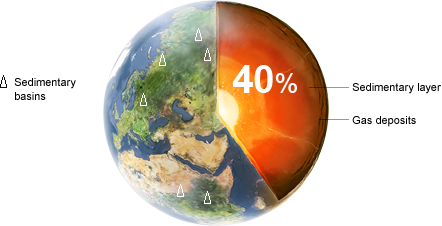
Gas and oil are born and accumulate in the sedimentary mantle of the Earth. Small amounts of these hydrocarbons are present throughout the mantle, but large accumulations are encountered less frequently. About 600 sedimentary basins, characterized by oil and gas occurrence, are found on the Earth. But only 40 per cent of those currently explored are productive.
Geoscientists’ maps
Oil and gas prospecting begins with geological surveys. Geological maps representing the structure of areas of the outer crust of the Earth are drawn upon the results of such survey.
In the course of field survey, geologists study outcropping rock beds, their composition, origin, age, and deposition forms. Boundaries of distribution of these rocks are plotted on topographical maps and areas of possible deposits of mineral fossils are outlined. These areas are further prospected and explored in detail; then, fossil minerals are initially estimated. Gravitational, magnetic, and seismic method are used to survey the subsurface.
Gravity prospecting
Magnetic prospecting
Seismic prospecting
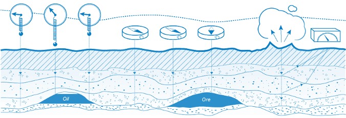
Gravity prospecting
Gravity prospecting is based on dependence of gravity on density of rocks: oil- or gas-bearing rocks have lower density than similar water-containing rocks. The mission of geoscientists is to find locations with abnormally low gravity.
Magnetic prospecting
Magnetic prospecting is based on different magnetic conductivity of rocks. Airborne magnetic survey enables the identification of anticlines – natural geological traps for migrating hydrocarbons at a depth of up to 7 kilometers.
Seismic prospecting
Seismic prospecting determines the structure of rock deposition using artificially created elastic oscillations (seismic waves) when passing though the stratum. In terms of physics, these are the same acoustic waves as on the surface, which resulted from a medium perturbance and reflected from a surface. Echoes of seismic waves are detected by seismographs. Seismic prospecting is used not only for finding structures, which can contain hydrocarbons, but also for the selection of an optimal site for drilling prospecting wells. Seismic method is often used in conjunction with drilling to enhance reliability of forecasting.
2D, 3D, and now also 4D
Conventional two-dimensional (2D) seismic prospecting has been gradually replaced with more modern three-dimensional (3D), i.e. scientists receive not a flat but stereoscopic image of a crust section, where fossil minerals may occur. Application of four-dimensional (4D) seismic prospecting is started as well – recurrent observations of the three-dimensional (3D) survey allow for better real-time control over the field development conditions.
Geochemical prospecting
There are also geochemical methods for prospecting hydrocarbon deposits based on studies of the chemical composition of underground water and the content of dissolved gases and organic matters in it. Concentration of these components in water increases as it approaches the deposit.
Drilling is reliable
However, the only method to know for sure whether a trap has commercial amounts of gas or oil is to drill a well. On average, only every third drilled well turns out to be a legitimate field.
Exploration: increased reserves
To increase the hydrocarbon reserves, the Energy Strategy of Russia provides for the development of geological exploration operations for the period until 2020 with a view to discovering new fields.
Gazprom Group is the world’s largest company in terms of natural gas reserves with its over 33 trillion cubic meters. Effective policy in the area of replenishment of hydrocarbon reserves helped the company achieve this result. Gazprom has secured excess of the reserves replenishment over the level of production since 2005.
Geological exploration remains one of the most effective means for increasing reserves. In 2010, prospecting and exploration operations enabled an increment of over 547.7 billion cubic meters of natural gas ensuring its replenishment rate of 108 per cent. Gazprom continues working on optimization of the volumes and improvement in efficiency of geological exploration in order to secure stable mid- and long-term production growth.

Gas condensate can be used to make both fuel and plastic.
The main thing is to stabilize it by removing unnecessary admixtures.
What is compressed (pressurized) natural gas
Gas is compressed in order to reduce its volume. But CNG as fuel is much more eco-friendly than oil. And it is supposed to gradually replace oil in Russia.